From 23 to 25 April 2025, a three-day webinar on “Copernicus for Land Degradation, Agriculture, and Food Security” was co-organised by the EU Space Support Office (EUSSO) in collaboration with the Regional Centre for Mapping of Resources for Development (RCMRD) – entity based in Kenya which includes 20 Contracting Member States across the Eastern and Southern African regions.
The event was very well received bringing together around 200 live participants per day among Copernicus experts, researchers, policymakers, and practitioners to highlight how Earth Observation (EO) data can support sustainable land management, agriculture, and food security in Eastern and Southern Africa.
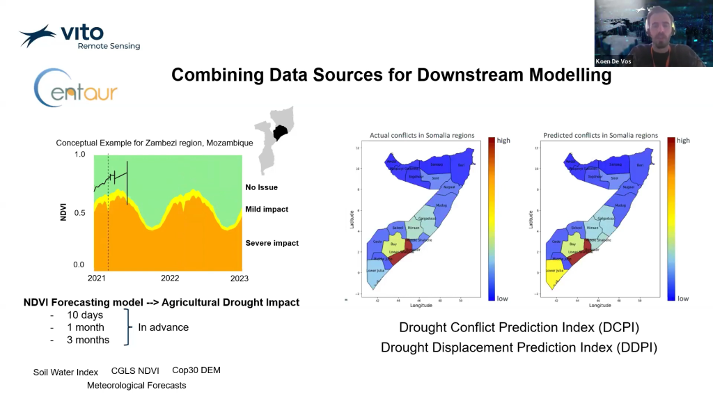
CENTAUR was featured on the second day of the programme, which focused on practical use cases that leverage Copernicus data and services. Our partner VITO Remote Sensing, represented by Ruben Van De Kerchove and Koen De Vos, introduced a series of innovative products developed within the CENTAUR Horizon Europe project, particularly in the area of agricultural drought monitoring.
A key highlight was the presentation of agricultural drought risk maps, tailored to different types of vegetation and regions, including Somalia, Mali, and Mozambique. As explained by Ruben Van De Kerchove, these outputs, when combined with other Copernicus products, have enabled the development of systems capable of forecasting the impact of drought on agriculture up to 10 days, one month, and even three months in advance.
In addition to monitoring drought conditions, the project is now taking a further step toward directly addressing food security and its societal impacts. In fact, CENTAUR has developed models which leverage Copernicus data to forecast potential conflicts and population displacement. In particular, these insights are made possible thanks to innovative indices such as the Drought Conflict Prediction Index (DCPI) and the Drought Displacement Prediction Index (DDPI) which have been developed in recent months as part of the project.
CENTAUR’s participation in the webinar not only underscored the project’s relevance to the African EO community but also provided a glimpse into the powerful tools under development. These tools exemplify CENTAUR’s broader mission: to improve the Copernicus Emergency Management and Security Services with timely, actionable, and policy-relevant information.
For the latest updates on CENTAUR activities and upcoming events subscribe to our newsletter and follow us on LinkedIn, X, and BlueSky.
Recordings of the three-day webinar on “Copernicus for Land Degradation, Agriculture, and Food Security” are available at:
Day 1 – Introducing Copernicus